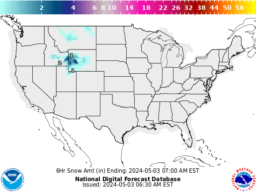
CURRENT 6-HOUR SNOWFALL FORECAST
Current forecast of total 6-hour snowfall accumulation in inches.
Snowfall Forecast |
| U.S. SNOW DEPTHS | CLOUD/PRECIP FCST MOVIE | TEMPERATURE FCST MOVIE | WEATHER QUESTIONS | ||
| NATIONAL RADAR | WATCHES & WARNINGS | STORM REPORTS | 2010 HURRICANES | ||
CURRENT 6-HOUR SNOWFALL FORECASTCurrent forecast of total 6-hour snowfall accumulation in inches.
|
DAILY SNOWFALL AMOUNTS FOR NEXT 3 DAYSComputer forecasts of 24 hour Total Snowfall amounts from the NWS/Meteorological Development Laboratory.(Updated twice a day; all times are EST) |
| DAY 1 |
| 24 hour snowfall forecast |
| Trace to 2" | 2" to 4" | 4" to 6" | 6" to 8" | 8+" |
| (1200 UTC = 7 a.m. to 7 a.m.)
(0000 UTC = 7 p.m. to 7 p.m.) (ending date coded as YYMMDD/ ) |
||||
| DAY 2 |
| 24 hour snowfall forecast |
| Trace to 2" | 2" to 4" | 4" to 6" | 6" to 8" | 8+" |
| (1200 UTC = 7 a.m. to 7 a.m.)
(0000 UTC = 7 p.m. to 7 p.m.) (ending date coded as YYMMDD/ ) |
||||
| DAY 3 |
| 24 hour snowfall forecast |
| Trace to 2" | 2" to 4" | 4" to 6" | 6" to 8" | 8+" |
| (1200 UTC = 7 a.m. to 7 a.m.)
(0000 UTC = 7 p.m. to 7 p.m.) (ending date coded as YYMMDD/ ) |
||||
|
|

|
| Copyright© 2010 WeatherStreet.com |